Abstract
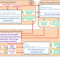
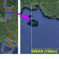
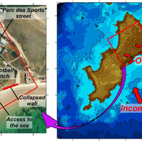
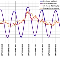
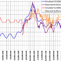
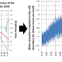
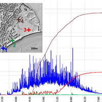
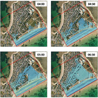
Recent dramatic events have allowed significant progress to be achieved in coastal flood modelling over recent years. Classical approaches generally estimate wave overtopping by means of empirical formulas or 1-D simulations, and the flood is simulated on a DTM (digital terrain model), using soil roughness to characterize land use. The limits of these methods are typically linked to the accuracy of overtopping estimation (spatial and temporal distribution) and to the reliability of the results in urban areas, which are places where the assets are the most crucial. This paper intends to propose and apply a methodology to simulate simultaneously wave overtopping and the resulting flood in an urban area at a very high resolution. This type of 2-D simulation presents the advantage of allowing both the chronology of the storm and the particular effect of urban areas on the flows to be integrated. This methodology is based on a downscaling approach, from regional to local scales, using hydrodynamic simulations to characterize the sea level and the wave spectra. A time series is then generated including the evolutions of these two parameters, and imposed upon a time-dependent phase-resolving model to simulate the overtopping over the dike. The flood is dynamically simulated directly by this model: if the model uses adapted schemes (well balanced, shock capturing), the calculation can be led on a DEM (digital elevation model) that includes buildings and walls, thereby achieving a realistic representation of the urban areas. This methodology has been applied to an actual event, the Johanna storm (10 March 2008) in Gâvres (South Brittany, in western France). The use of the SURF-WB model, a very stable time-dependent phase-resolving model using non-linear shallow water equations and well-balanced shock-capturing schemes, allowed simulating both the dynamics of the overtopping and the flooding in the urban area, taking into account buildings and streets thanks to a very high resolution (1 m). The results obtained proved to be very coherent with the available reports in terms of overtopping sectors, flooded area, water depths and chronology. This method makes it possible to estimate very precisely not only the overtopping flows, but also the main characteristics of flooding in a complex topography like an urban area, and indeed the hazard at a very high resolution (water depths and vertically integrated current speeds). The comparison with a similar flooding simulation using a more classical approach (a digital terrain model with no buildings, and a representation of the urban area by an increased soil roughness) has allowed the advantages of an explicit representation of the buildings and the streets to be identified: if, in the studied case, the impact of the urbanization representation on water levels does indeed remain negligible, the flood dynamics and the current speeds can be considerably underestimated when no explicit representation of the buildings is provided, especially along the main streets. Moreover, on the seaside, recourse to a time-dependent phase-resolving model using non-stationary conditions allows a better representation of the flows caused by overtopping. Finally, this type of simulation is shown to be of value for hazard studies, thanks to the high level of accuracy of the results in urban areas where assets are concentrated. This methodology, although it is currently still quite difficult to implement and costly in terms of calculation time, can expect to be increasingly resorted to in years to come, thanks to the recent developments in wave models and to the increasing availability of LiDAR data.
Figures
Register to see more suggestions
Mendeley helps you to discover research relevant for your work.
Cite
CITATION STYLE
Le Roy, S., Pedreros, R., André, C., Paris, F., Lecacheux, S., Marche, F., & Vinchon, C. (2015). Coastal flooding of urban areas by overtopping: Dynamic modelling application to the Johanna storm (2008) in Gâvres (France). Natural Hazards and Earth System Sciences, 15(11), 2497–2510. https://doi.org/10.5194/nhess-15-2497-2015
