The coherence of small island sea level with the wider ocean: A model study

17Citations
Citations of this article
17Readers
Mendeley users who have this article in their library.

Abstract

Studies comparing tide gauge measurements with sea level from nearby satellite altimetry have shown good agreement for some islands and poor agreement for others, though no explanation has been offered. Using the 1/12 OCCAM ocean model, we investigate the relationship between sea level at small, open-ocean islands and offshore sea level. For every such island or seamount in the model, we compare the shallow-water sea level with the steric and bottom pressure variability in a neighbouring ring of deep water. We find a latitude-dependent range of frequencies for which off-shore sea level is poorly correlated with island sea level. This poor coherence occurs in a spectral region for which steric signals dominate, but are unable to propagate as baroclinic Rossby waves. This mode of decoupling does not arise because of islands bathymetry, as the same decoupling is seen between deep ocean points and surrounding rings. © 2012 Author(s).

Figures

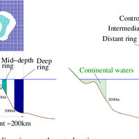
  • Fig. 1. Illustration of island waters and surrounding rings, and control regions.
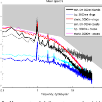
  • Fig. 2. Mean spectra of shallow-water sea-surface height (h) (black/grey), and deep-water steric (φ) (red) or bottom pressure (p) (blue) contributions to sea-surface height. Heavy curves are for spectra averaged over islands (h) or surrounding deep rings (φ,p). Lighter curves are for continental shelves (h) or deep water open ocean (φ,p). Polar regions are excluded. Background shading indicates power proportional to σ−1/2 and σ−2.
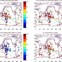
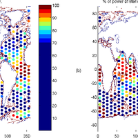
  • Fig. 3. Percentage of variance of h at island explained by h (a, c, d) or p (b) in a neighbouring ring of water 3000 m deep (a–c) or 500–1000 m (d). (b) and (c) have 0–6 month high-pass and 18+ month low-pass filters applied respectively; (a) and (d) are unfiltered.
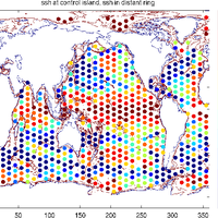
  • Fig. 4. Percentage of variance of h at “control island” explained by h in a 5◦ diameter ring.
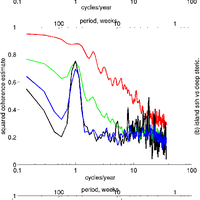
  • Fig. 5. Magnitude squared coherence estimate by frequency for sea-surface height at island and (a) sea-surface height (h), (b) steric height (φ), and (c) bottom pressure (p), in deep water nearby, averaged over latitude bands.
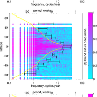
  • Fig. 6. Magnitude squared coherence of sea-surface height at island and (top to bottom) (a) sea-surface height (h), (b) steric height (φ), and (c) bottom pressure (p), in deep water nearby, for every island by latitude and frequency. Pink dots indicate a high coherence and blue low. Black bars emphasize the transition region between dominance of γhφ and γhp . Linear baroclinic Rossby waves are possible only to the left of the yellow line.
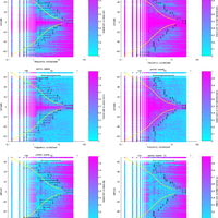
  • Fig. 7. Magnitude squared coherence of sea-surface height at “control island” and (panels from top to bottom) sea-surface height (h), steric height (φ), and bottom pressure (p), in surrounding ring. Left-hand panels are for distant ring, right-hand panels intermediate rings. Coherence is plotted for every island by latitude and frequency; pink dots indicate a high coherence and blue low. Black bars emphasize the transition region between γhφ and γhp . Linear baroclinic Rossby waves are possible only to the left of the yellow line.
  • Fig. 8. (a) Percentage of variance of φ at “control island” explained by φ in a 2.5◦ neighbouring ring. (b) Percentage of the power spectrum in φ at the “control island” that has frequency lower than the Rossby frequency at that location. Note change of scale from earlier maps.

References Powered by Scopus

Geographical variability of the first baroclinic Rossby radius of deformation

1273Citations
N/AReaders
Get full text

Calibration of TOPEX/Poseidon and Jason altimeter data to construct a continuous record of mean sea level change

248Citations
N/AReaders
Get full text

Coastal altimetry

195Citations
N/AReaders
Get full text

Cited by Powered by Scopus

Sea-level science: Understanding tides, surges, tsunamis and mean sea-level changes

356Citations
N/AReaders
Get full text

Recent updates to the Copernicus Marine Service global ocean monitoring and forecasting real-time 1g 12° high-resolution system

338Citations
N/AReaders
Get full text

Forcing Factors Affecting Sea Level Changes at the Coast

219Citations
N/AReaders
Get full text

Register to see more suggestions

Mendeley helps you to discover research relevant for your work.

Already have an account?

Cite

CITATION STYLE

APA

Williams, J., & Hughes, C. W. (2013). The coherence of small island sea level with the wider ocean: A model study. Ocean Science, 9(1), 111–119. https://doi.org/10.5194/os-9-111-2013

Readers over time

‘12‘13‘14‘15‘16‘17‘18‘20‘22‘23‘2401234

Readers' Seniority

Tooltip

PhD / Post grad / Masters / Doc 9

60%

Researcher 4

27%

Professor / Associate Prof. 2

13%

Readers' Discipline

Tooltip

Earth and Planetary Sciences 12

80%

Physics and Astronomy 2

13%

Agricultural and Biological Sciences 1

7%

Save time finding and organizing research with Mendeley

Sign up for free
0