Potential and limitations of risk scenario tools in volcanic areas through an example at Mount Cameroon

16Citations
Citations of this article
30Readers
Mendeley users who have this article in their library.

Abstract

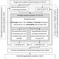
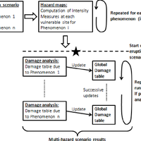
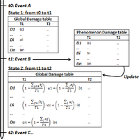
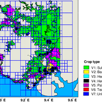
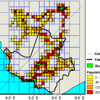
This paper presents an integrated approach to conduct a scenario-based volcanic risk assessment on a variety of exposed assets, such as residential buildings, cultivated areas, network infrastructures or individual strategic buildings. The focus is put on the simulation of scenarios, based on deterministic adverse event input, which are applied to the case study of an effusive eruption on the Mount Cameroon vlcano, resulting in the damage estimation of the assets located in the area. The work is based on the recent advances in the field of seismic risk. A software for systemic risk scenario analysis developed within the FP7 project SYNER-G has been adapted to address the issue of volcanic risk. Most significant improvements include the addition of vulnerability models adapted to each kind of exposed element and the possibility to quantify the successive potential damages inflicted by a sequence of adverse events (e.g. lava flows, tephra fall, etc.). The use of an object-oriented architecture gives the oportunity to model and compute the physical damage of very disparate types of infrastructures under the same framework. Finally, while the risk scenario approach is limited to the assessment of the physical impact of adverse events, a specific focus on strategic infrastructures and a dialogue with stakeholders helps in evaluating the potential wider indirect consequences of an eruption.© 2013 Author(s).

Figures

  • Fig. 1. Idealized scheme of a risk scenario builder tool as obtained after collecting and assimilating high level requirements from a group of users, geologists and computer scientists.
  • Fig. 2. UML (Unified Modeling Language) class diagram of the studied infrastructure, adapted from Cavali ri et al. (2012).
  • Fig. 3. Modelling example of the part of a water supply system, using the object-oriented structure.
  • Fig. 4. Top: hazard projection procedure on linear and area-like vulnerable sites. Bottom: example of damage analysis for a hypothetical case, where, by way of example, the edge is assigned a deterministic model, and the cell a probabilistic model for which the cell contains a proportion %T 1 of building typology 1, with a collapse fragility function.
  • Fig. 5. Flow chart implemented in the toolbox for a multi-hazard scenario.
  • Fig. 5. Flowchart implemented in the toolbox for a multi-hazard
  • Fig. 8. Representation of cultivated-area polygons and projection on the generated mesh grid.
  • Fig. 7. Projection of built areas around Mount Cameroon on the generated mesh grid and representation of population density within cells.

References Powered by Scopus

275Citations
439Readers
Get full text
Get full text
196Citations
196Readers
Get full text

Cited by Powered by Scopus

This article is free to access.

27Citations
85Readers

This article is free to access.

Get full text

Register to see more suggestions

Mendeley helps you to discover research relevant for your work.

Already have an account?

Cite

CITATION STYLE

APA

Gehl, P., Quinet, C., Le Cozannet, G., Kouokam, E., & Thierry, P. (2013). Potential and limitations of risk scenario tools in volcanic areas through an example at Mount Cameroon. Natural Hazards and Earth System Sciences, 13(10), 2409–2424. https://doi.org/10.5194/nhess-13-2409-2013

Readers over time

‘14‘15‘16‘17‘20‘21‘23‘24‘2502468

Readers' Seniority

Tooltip

PhD / Post grad / Masters / Doc 10

59%

Researcher 6

35%

Professor / Associate Prof. 1

6%

Readers' Discipline

Tooltip

Earth and Planetary Sciences 9

56%

Engineering 3

19%

Environmental Science 3

19%

Computer Science 1

6%

Save time finding and organizing research with Mendeley

Sign up for free
0